Highland County in the Fall

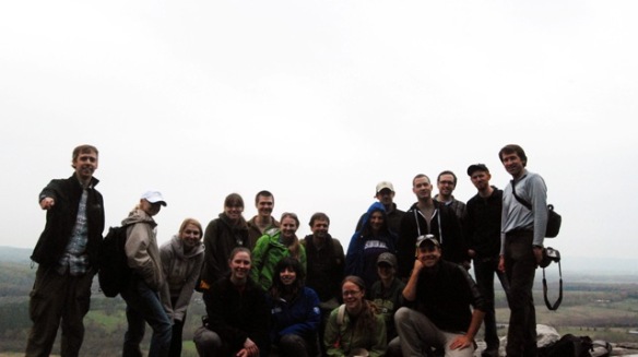
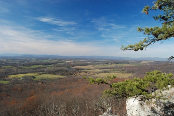
This past weekend I had the opportunity to spend time out in Highland County Virginia. I am involved in a mapping project of the Monterey SE Quadrangle. First of all, I have to say that the views and fall colors were absolutely amazing. The image below was taken along the ridge of Jack Mountain just north of Sounding Knob outside of Monterey, VA.

Not only that, the geology was fantastic. Among the more interesting things I saw were some folds of the Appalachian Fold Belt (Small and Large Scale) , cross-bedding, and crinoids roughly the diameter of a quarter.

The image below shows some of the large pink crinoid stems in the New Creek formation of the Helderberg Group. They are Devonian in age.

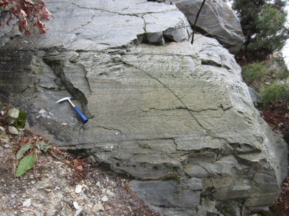
Here is some cross-bedding in the Tonoloway. This sandy layer marks the boundary between the lower and middle un-named members of the Tonoloway Formation. It is Silurian in age.

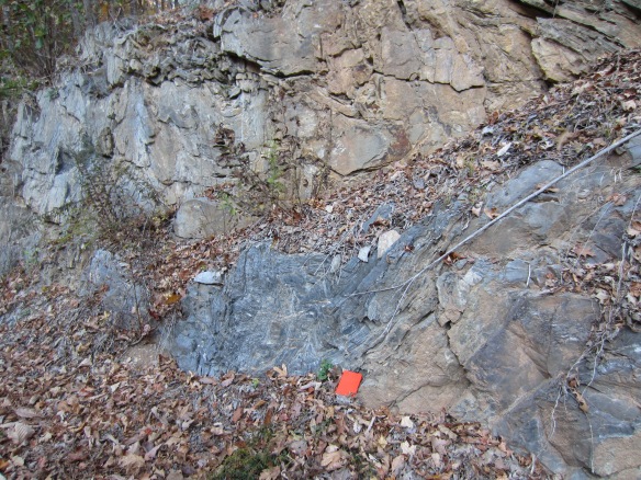
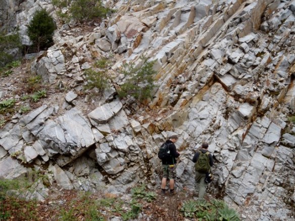
This following images show the intense folding of the Wills Creek Formation along route 250 east of Monterey. It is part of the Cayuga group.  This is located near the axis of an anticline. It is Silurian in age.

A Bejeweled Fold

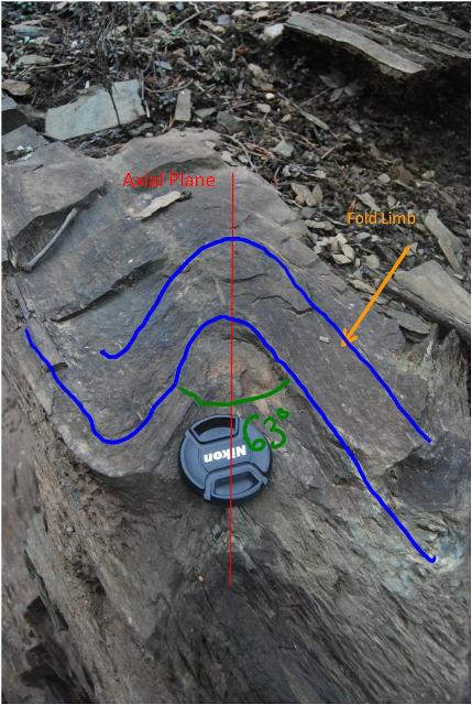
As you all may have noticed I have been a little quite this summer.  That is because I have barely had more than a week at a time at home this summer.  Between a 5 week geology field camp (which was amazing) and family trips to California and Tennessee, it has been a busy summer.  Now that the Fall semester has started up and things have settled back down I can get back to sharing some of the cool things I have found out in the field.  This is just going to be a quick post to ease myself back into the habit.  Below is a picture of one of the folds we came across out in New Mexico this summer during my field course.  Not only is it a fold but the garnets formed as garnetiferous layers aligned with the bedding planes which were  being folded.  I thought this was incredible.  It was in the Rinconada formation and this member appeared to be a Garnet White Mica Schist.  Sadly, upon returning home I realized that the picture did not turn out as well as I had hoped but it is still pretty neat.

Structural Geology Weekend Field Project

Photo coutesy of Callan B.

This past weekend my structural geology class took a weekend long trip out to the Blue Ridge and Valley and Ridge Geologic Providences of Virginia.  Our intention was to spend the weekend working our way through the structural history of Virginia’s geology.  Our first day and a half was spent in the Blue Ridge Anticlinorium.  We then spent the remainder of Saturday in the Valley and Ridge Province within the Massanutten Synclinorium.  Sadly, the weather was uncooperative and we were forced to call it quits Saturday night instead of camping at Massanutten and exploring the structures along the new Route 55 in West Virginia.  In this post I will attempt to narrate the structural history of Virginia from 1100 Ma to roughly

First the Blue Ridge

*An important point to make is that when the Appalachian Orogeny is refered to I am referring to the three main orogenies that affected the east coast of North America culminating in the formation of Pangea.  These orogenies include the Taconian, Acadian, and Alleghenian.  The Taconian and Alleghenian were the primary forces in the Blue Ridge with the Alleghenian having the largest affect.  This being said, it is difficult to tell which of the three imparted a specific deformational feature on the rocks we were seeing.

Working our way up…

Level 1: The Basement

The lowest portion of rock we encountered was the basement complex.  The basement complex is comprised of a series of granitic and metamorphic rocks which formed some 1.1 billion years ago.  This was during the Grenville Orogeny.  The basement is very complex being made up of various types of igneous and metamorphic rocks.  The region of the Blue Ridge where we were was mostly made up of granites and various grades of metamorphic rocks.  As the orogeny progressed the oblique angle of collision between the continents caused shear zones to form in the basement.  One such zone which we visited was the Garth Run High Strain Zone (GRHSZ).  Within the shear zone we had the opportunity to see several deformational features.  We saw various stages of mylonitic textures.

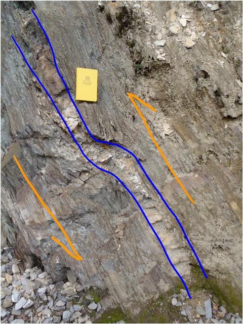
The image above shows the GRHSZ.  The annotations in the image show that the amount of shearing increases across the outcrop from left to right.  This is expressed by the amount of foliation which increases from least on the left to most on the right.  This trend indicates that the center of the shear zone is off to the right in this image. 

On a regional scale the shear zones fill the center of the Blue Ridge anticlinorium.  The shear zones form an anastamosing pattern much like that of river with multiple oval shaped islands. 

So, for showing off the zones, logically one starts with areas that display the least shear and working our way up.  As shearing develops a rock first becomes micro-brecciated meaning it begins to break up into clasts similar to a small scale fault breccias.  Once shearing continues we are into a the mylonitic structures.  When the process stops with 10-50% of the rock is still crushed matrix while the remaining precentage porphyroclasts.  If the process stops at this point we have what is called a protomylonite.  There were no true protomylonites but there were some low grade mylonites.  Unfortunately I failed to take any pictures.

            If the process shown above continues even farther we get into the realm of mylonites where 50-90% of the rock is matrix with the rest being made up of porphyroclasts.  An interesting thing to note is that once again the large regional scale structure is shown in the small scale structures.  You will have to excuse the picture.  The good mylonites were on the opposite side of a patch of poison ivy and seeing as it was the first day I did not want to tempt fate and try to pick my way through them.

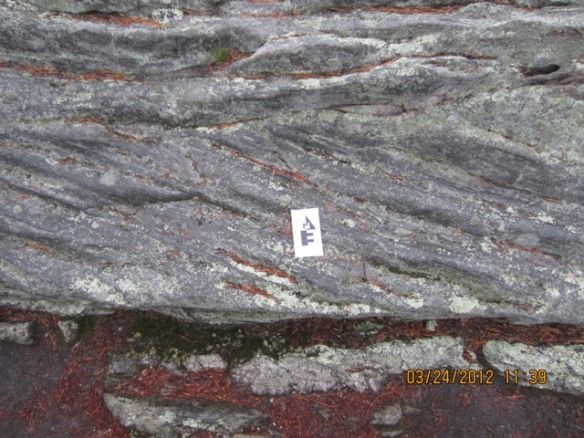
            Finally is the rock has been completely sheared out and smeared to bits we have a ultramylonite.  In such cases 90% or more of the rocks is matrix with 10% or less of the rock being porphyroclasts.  This is shown below.  It almost looks like lamellar bedding in sedimentary rocks.
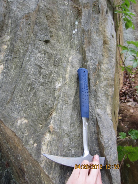
Another feature we found in the shear zone was a fold which was upright.  Unfortunately it was outside our ability to safely reach in order to take measurements.  Based on the Fleuty Fold Classification system I would call it steeply inclined and gently plunging.  Under the Hudleston Classification system it would be an E4.  The picture below shows the fold.

We also found some feldspar boudinage in the outcrop.  This forms due to compressive forces where two directions of similar strength are stronger than the third causing the feldspar to become prolate.  Eventually the feldspar breaks and the space is filled by the surrounding rock.  It looks like sausage links which is how it got its name from the german word for sausage.  This is shown below.

Augen are also visible in the outcrop.  These are feldspars that have been sheared into an eye-like shape.  In fact the work augen is the German word for eye.  The process is similar to boudinage except on a smaller scale without the feldspar breaking.


Level 2:  The Swift Run

Our next stop in our chronological elevator was the Swift Run Formation.  In fact, we were lucky enough to visit the type locality for the formation.  This is a feldspathic arenite sandstone which has some conglomeratic areas and mud lenses.  The formation was deposited during the post-Grenville rifting.  Since undergoing diagenesis the sediment has been lightly metamorphosed and now exhibits foliation which will be discussed later.  At the time of deposition the formation contained various primary sedimentary features.  The first one that I noticed was the graded bedding shown below. 

The graded beds indicate a marine or fluvial environment which experienced pulses of energy such as floods or turbidity currents.  Such impulses move large amounts of sediment and then quickly lose energy.  Such a rapid loss of energy causes a distinct depositional pattern.  As the energy decreases sediment falls out of suspension.  The size of particles water is able to carry is directly related to the amount of energy in the system.  In other words as the system loses energy (in this case the water’s flow rate decreases) the particle size which it can carry decreases.  This results in the largest particles falling out of suspension first followed by progressively smaller particles.  The same result occurs when the energy is abruptly removed from the system, the largest particles settle first followed by increasingly smaller ones. 

Swift Run Cross-Bedding

Another structure we found was cross bedding.  This indicates current.  Cross beds can be formed by either air currents or water currents.  In this case the grains are too coarse to be Aeolian deposits.  Another interesting feature of cross beds is that they can be used as geopedal indicators.  The truncated side of the cross beds points in the original up-column direction from deposition.

Also in the swift run formation were some rip-up clasts.  This is where mud clasts were ripped up by currents.  Then, the clasts were deposited with the rest of the Swift Run Formation.  Since then they have been strained and made oblate.

Here is the bedding and cleavage data showing that the beds are not overturned.

Level 3:  The Catoctin Formation.

            The Catoctin Formation is a unit of flood basalts which originated during the rifting of Rodinia.  After millions of years as a supercontinent, heat began to build up under the interior of the continent.  As the heat reached the bottom of the lithosphere it spread out beginning to pull the continent in multiple directions.  As shown in failure envelopes the tensile strength of a rock is far weaker than the compressive strength of the same rock.  This resulted in rifting.  Where the rifts formed the were thin weak spots in the crust which allowed basalts to flow up to the surface and flood the area.  The Catoctin was one such flood basalt.  Many people associate basalt with a black color.  Today, the Catoctin is actually a shade of green.  This is the result of epidotization during the Appalachian Orogenies.  Because of its green nature the Catoctin is commonly called the “Catoctin Greenstone”.  The Catoctin Formation shows many primary structures from deposition as well as several features from alteration during the orogenies. 

Perhaps the most fantastic feature of the Catoctin Formation is that in many places it is present as dikes.  When Rodinia split, feeder dikes opened up throughout what is now the Blue Ridge in order to facilitate the outpouring of basalt.  Many of these dykes are still visible in the underlying strata.  Typically these dikes trend north-east to south-west.  We found several along Skyline Drive in Shenandoah National Park.  Below is a picture of one such dike. 

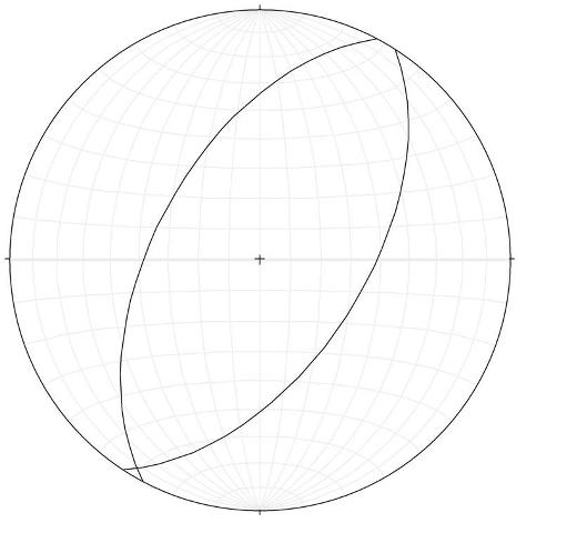
We had the opportunity to measure its orientation and found that it had a south-east strike and a dip to the west.  Below is a stereonet depicting the orientation of the dyke we measured in blue.  The black planes are the orientations of several of the dykes one climbs through when hiking Old Rag Mountain which are also Catoctin feeder dikes.
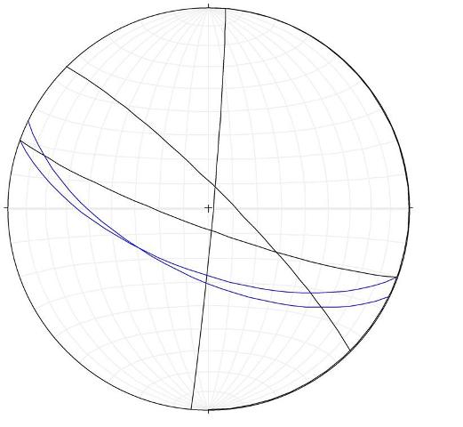
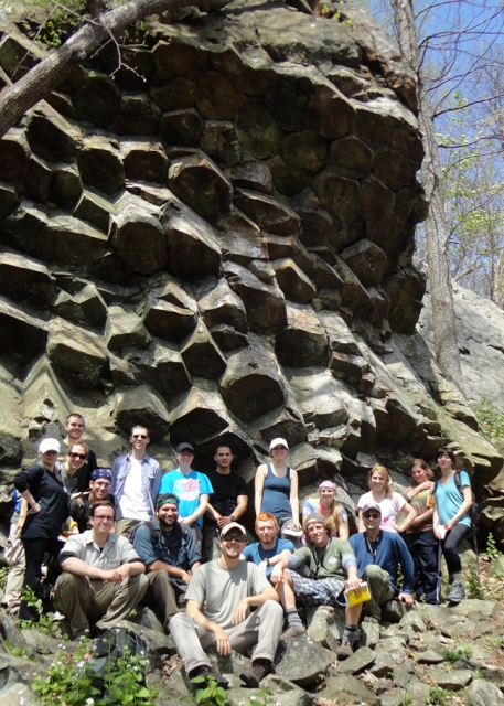
When the basalt reaches the surface it instantly begins to cool.  AS with many things when cooling occurs relatively rapidly it leads to brittle deformation, in this case fracturing.  In several places throughout the national park basaltic columns are visible.  These form when the lava cools from top to bottom with the top cooling faster with slower cooling occurring deeper and deeper in the flow.  As the rock cools it contracts and fractures form.  These fractures tend to form as triple joints.  The principle is similar to that of mud cracks or even triple rifts on the plate tectonics scale.  The joints then expand meeting with other triple joints forming polygons on the cooling surface, the most common being hexagons.   These sets of joints then propagate in the direction of cooling forming columns.  The same thing occurs from the contact with the ground under the flow and works upward.  Eventually the two meet in the middle.  The picture at the top of this post shows some of the columns at Compton Peak in the background.

  We had the opportunity to visit two sets of columns on our trip.  One set was along the Limberlost trail and the other was on Compton Peak.  We were tasked with evaluating these columns.  One of our primary objectives was to measure the columns and find out what was different between them. 

The Limberlost Columns:

            These columns had obviously been sheared.  The question became how much? And what did this do to the angle of the triple joints? 

I first calculated the angular shear of the columns.  I did this by measuring the angle between the top of the  most acute angle I could find between the top of the column and a face.  From my vantage point Y=+45.  From this I used the equation angular shear g=tanY.  The result was an angular shear of 1.

Photo courtesy of Maya A.

Another part of working in the field is learning as you go.  I didn’t have a good way of measuring the interior angles of the sheared columns while we were on the Limberlost Trail.  While we were there I used a protractor to measure the angles.  Unfortunately, because of the between the side of the column and the top the measurements were likely distorted.  Even so, the data does show some of the alteration in angles caused by the shear.  We measured a 7 sided column.  As with any 7 sided polygon the sum of the interior angles should be approximately 900 degrees.  For this one it was 909.0 degrees.  Starting in one triple joint and working around the edge the angles are as follows.  150, 110, 145, 145, 110, 116, and 135 degrees.  On a standard septagon the interior angles are each 128 degrees.  In this case, the interior angles of the polygon that are in line with the shear direction are decreased and those “perpendicular” to the shear direction are expanded.  This is shown in the picture below.

Photo courtesy of Laura S.

COMPTON PEAK

After visiting the Limberlost Trail we did the Compton Peak Trail which lead to some of the most incredible columnar jointing on the east coast.  Here we are viewing the columns from the bottom.  These columns are not sheared as the ones at the Limberlost Trail were.  This gives us a look at unaltered columns.  For these columns there was no angular shear.  However I did need to measure the interior angles.  For this, I had asked a few questions, thought about my method a little, and came up with a better way of measuring the angles.  I decided to measure the orientation of the column faces and then use stereonets to find the interlimb angles.  This is shown below.  The planes for column 2 are in red.  The calculated interlimb angles were as follows, for column 1 one was 128.5 and the other was 146 degrees.  For column 2 one angle was 120 and the other was 158 degrees.

One of the most common features of the catoctin formation is the large quantity of amygdules.  Amygdules which are a secondary feature, were once vesicles a primary feature.  When the basalts first reached the surface and spread out they began to degas.  Bubbles of gas began to rise to the surface of the flows trying to escape.  Some of the bubbles made and others didn’t.  The ones that failed to escape were trapped, concentrated near the top of the flows, for all time.  Then, later, fluids begain to percolate through the rocks, particularly during the Appalachian Orogeny.  It was at this time the minerals began to crystallize in the cavities left by the gas bubbles forming amygdules.  Most commonly one finds epidote amygdules.  Sadly none of my amygdule pictures turned out well from this trip so I had to pull the picture below from another trip I took into the field.  This picture was taken along I-64 east of the Skyline Drive Entrance.

Also in the Catoctin are areas of volcanic breccias which are the result of pyroclastic flows or lahars.  Both of which are unconsolidated flows of volcanic material which result in an angular conglomeratic rock as shown below.

Level 3: The Chilhowee Group.

We had two opportunities to view formations from the Chilhowee Group during our field trip.  The first came on day 1 when we finished early.  We then proceeded to visit an outcrop of the Harpers Formation (The middle formation of the Chilhowee Group) in Beldore Valley. 
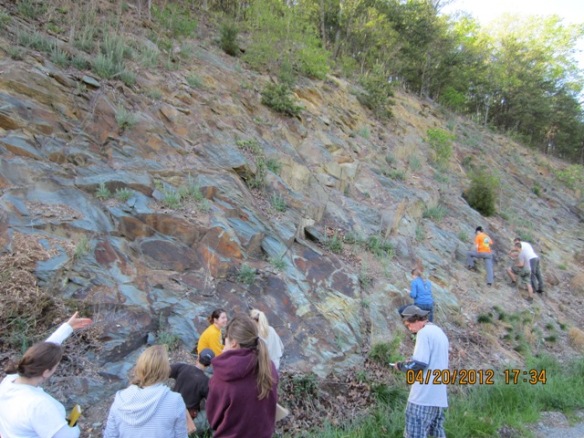
It is typically brown with particle sizes from mud sized particles and areas of sand size particles which were deposited after the rifting of Rodinia.  The sediment was also metamorphosed during the Appalachian orogeny. Since we were on the western edge of the Blue Ridge I was excited to find evidence of the overturn.  As such I began looking for bedding and cleavage relationships.  When bedding and cleavage both dip in the same direction and the bedding dips more steeply it is likely that you are viewing an overturned bed.  Sadly, this was not the case here.  The data I collected is shown below (Bedding is in blue).

While I was unable to find the relationship I was looking for on the Structure Field Trip, I did find evidence of the overturn just this past weekend.  It is shown below in all its overturned glory.

Another feature we saw in the Harpers Formation was Boudinage of feldspar veins.  During the Appalachian Orogeny the region underwent compression where there were two primary forces  d1 and d 2 were stronger than the d 3 thus the feldspars were smashed into a cigar shape also known as prolate.  Eventually, the feldspars broke and the space between was filled in by the softer rock.  This is shown below.
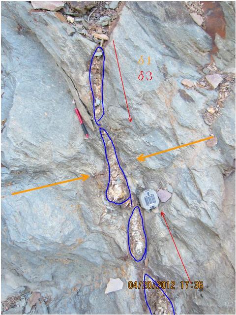
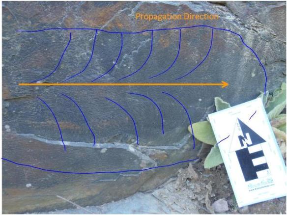
There were also fantastic plume structures which indicated the propagation direction of the fractures creating joints in the rocks which is shown below.
We also saw the Antietam Formation in the roadside walls of Skyline Drive.  The Antietam is a relatively pure white sandstone which is known for its abundance of skolithos tubes which will be discussed below.  While the slabs of rock were float, they still told an amazing story of the processes undergone by the sandstone.

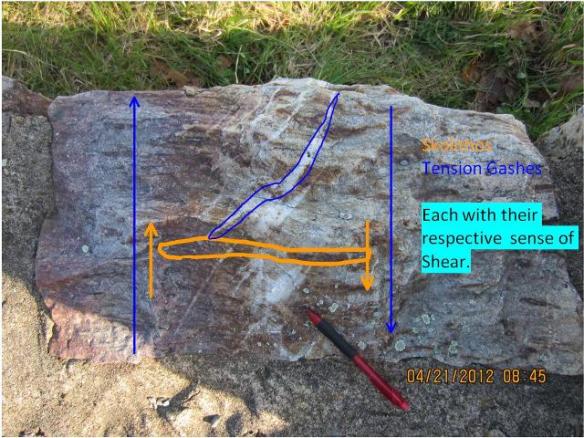
The trademark features of the Antietam Formation are the skolithos tubes which are common in the formation.  Skolithos are trace fossils of worm tubes.  The sediment that makes up the formation was an ancient shallow marine environment in which worms lived.  The worms used to burrow their way down into the sand.  These tubes were then filled in by other sediment and then lithified preserving the tubes.  Another interesting factoid is that the worms always burrowed straight down.  This makes the skolithos tubes useful geopedal structures as shown below.

There are also tension gashes in some of the slabs.  These form when the rock is being sheared.  Fractures then form along weak zones and open up into gashes which are then filled by mineral bearing solutions (in this case bearing silica) which then crystallize.  When several gashes form in a line they are known as en echelon tension gashes.  A neat attribute of some of the tension gashes shown below is that they were further sheared after they formed giving them a distinctive S shape.  Even more interesting are the skolithos tubes that are bisected by the tension gashes.  These reinforce the sense of shear.
Part Two: The Massanutten Synclinorium

            The Massanutten Sunclinorium shown below is located in the Valley and Ridge Province of Virginia.  It was formed during the Alleghenian Orogeny.  While at Massanutten we did some detailed analyses of the parasitic folds in Veach Gap.  There were a series of 3 anticlines and 3 synclines located up in the gap.  Before the rain hit I had time to get data from 3 of the six folds which I then called anticline 1, syncline 1, and anticline 2.  For each I took readings for the limbs in order to use stereonets to find the axial hinges.  All of the folds appeared to be disharmonic and concentric.  The three folds were arranged as shown below.

Anticline 1:

Under the Fleuty system of classification this would be an upright gently plunging fold with a Hudleston Classification of 4E to C3. 

The plunge and trend of the axial hinge is 37.2° à008.1°

Syncline 1:

The hinge of this fold was submerged beneath the soil so it was impossible to give it the proper classification and descriptions.  The stereonet data for the syncline is shown below.

The plunge and trend of the axial hinge is 03.6° à210°

Anticline 2:

This was another upright, gently plunging fold with a Hudleston Classification of E3. 

The plunge and trend of the axial hinge is 25.6° à214°

Sadly, this was the end of our trip.  Beyond this point the weather was most uncooperative so we had to call it quits early and that was the end of our trip which started 1 billion years in the past and finished up 500 million years ago.  Mind you we took a short cut making it in only 2 days while the rocks had to take the long route.  Untill next time…

Thoroughfare Gap

            A week or so ago my structural geology class took another field trip.  This time we went to Thoroughfare Gap located near Haymarket Virginia.  The location is a water gap in the Bull Run Mountain created by Broad Run, a tributary of the Occoquan River.  The gap has provided a vital means of transportation across Bull Run Mountain.  During the civil war it was a strategic position from which one could control the passage of armies and good s from the Shenandoah Valley into the east.  Today the gap is used by the Broad Run, a train track, and two highways (Interstate 66 and Route 55).

            Aside from its geographic value Thoroughfare Gap shows evidence of a diverse series of tectonic events.  Thoroughfare Gap is located on the border between the Blue Ridge and the Piedmont geological provinces of Virginia.  Bull Run Mountain shows geologic features from one and a half Wilson Cycles.  Wilson Cycles are the process by which the continents alternate between being arranged together as supercontinents and being spread out across the earth.  The cycle takes roughly 600 Ma between supercontinents.  This is thought to be caused by heat from within the crust, convection cells within the earth’s mantle move material and heat up from the core mantle boundary which then spreads as it hits the surface along spreading centers.  I will now attempt to explain the complicated history of Thoroughfare Gap.

            The first story told by Thoroughfare Gap is that of the breakup of Rodinia which occurred 650 Ma ago.  This was known as the Post-Grenville Rifting.  We shall begin our tour at the western edge of the gap where the evidence of the rifting is readily apparent.  During periods where supercontinents exist excess heat builds up underneath them.  This heat then causes rifting.  As Rodinia broke apart there was a decrease in pressure in the upper mantle which allowed for melt to form.  This melt then spilled onto the surface in the form of the Catoctin Flood Basalt.  The Catoctin can also be seen in Shenandoah National Park as igneous dikes in the Old Rag Granite.  This was the oldest formation we saw on our trip.  Since its deposition it has undergone metamorphism, today the basalt is known as the Catoctin Greenstone. Originally it was a microcrystalline, mafic igneous rock.  When Rodinia broke up the area that is now Thoroughfare Gap became the shoreline of the Proto-Atlantic or Iapatus Ocean.  Then, after the break-up of Rodinia sediment began to accumulate.  During the early Cambrian the Chilhowee Group was deposited.  The Chilhowee Group is made up of the Weverton, Harpers, and Antietam Formations.  Of these three the Weverton and the Harpers are exposed at Thoroughfare Gap.  The Weverton is located just above the Catoctin stratigraphically.  At Thoroughfare Gap it was a quartz arenite which has since been metamorphosed into a quartzite.  The nature of the sandstone shows that this was once an ancient beach.  Regions of the formation are made up of oligomict quartzose paraconglomerates.  Above the Weverton is the Harpers which is a thin bedded shale with lenses of sand.  This shows that there was a shift to a lower energy environment.  This was likely a lagoon area.  According to Hess’s Law which states that vertical changes in stratigraphy represent the horizontal changes, this represents a transgressive sequence where sea level rose.  In other localities the Antietam Formation overlies the Harpers, but at Thoroughfare gap this is an unconformity.  In the area that we are interested all of these layers dip to the west.  It is necessary to clarity’s sake that this is stated now, however, the evidence for this will be explained later.

            Now we get into the convergent part of the Wilson Cycle.  Eventually the Iapatus Ocean began to close back up resulting in a series of continental collisions which made up the Appalachian Orogeny.

Map by Ron Blakey

            First, around 460 Ma during the Mid-Ordovician to Mid-Silurian the Taconian Orogeny took place.  During this time the Chopawamsic Terrane collided with what is now the east coast of the North American Plate.  Then, at 360 Ma the microcontinent Avalonia impacted on the North American Plate.  Finally the Iapatus Ocean closed completely as the African Plate crashed into the North American Plate in what was known as the Allegenian Orogeny which formed Pangea roughly 275 ma.  Strucural features throughout the area are evidence of the Appalachian Orogeny.  We will begin our tour of these features in the oldest rocks and then move up column into the younger rocks.

            Following the railroad tracks provides a unique opportunity to observe an east-west cross section of the structural features of Bull Run Mountain.  In many places the railroad company had to remove portions of the rock exposing fresh faces which show the true, unweathered traits of the rocks and the structures they are a part of.

            In the Catoctin Flood Basalts there are four features which show the east-west compression in the region.  First of all, the basalt has been metamorphosed into the Catoctin Greenstone.  Below is an image of the greenstone which is prominent in much of the Blue Ridge Geological Providence of Virginia. 

            The feature I found farthest to the west was a small fold in the rocks on the north side of the railroad track.  It is a close fold meaning the interlimb angle is less than 90°.  The straight limbs and hinge make it a chevron fold.  It is overturned and harmonic.  The orientation of this fold indicates that the primary stress (d1) was compressing the area along an east-west axis. 

Next, moving upward in the stratigraphic column (Moving east along the train tracks in our case) I came across another fold.  This one was much more rounded than the previous fold.  It is also harmonic, this one is upright, and it is also a close fold. 


Below is the same image annotated.

The next feature is what may have been a boudinage or perhaps a “proto-boudinage” which I found in a wall on the south side of the tracks.  This is where the compressive forces forced a rigid material (in this case what appears to be feldspar) to smear and fracture.  The less rigid meta-basalt then fills in between the fragments of the feldspar.  In this case the direction of least stress (d3) is nearly vertical with the two other stresses being north-south and east-west.

Below is the same picture annotated.  d2 would be into the page.

Next we move into the Weverton Formation.  It is important to note here that while we are moving up-column and that this formation is younger than the Catoctin the structural features mentioned here are roughly the same age as those in the Catoctin below.  This formation includes some of the more interesting structural features of the area.  At the least, it was the area that we focused on the most during our field trip. 

            The Weverton Formation contains various sets of joints which are shown in the picture below.

Photograph courtesy of Laura S.

Along with these joints we found plume structures everywhere.  The plumes are interesting because they tell the story of how the joints formed.  When a joint forms the direction of propagation is in the direction in which the plume opens.

Again, below is the same image annotated.

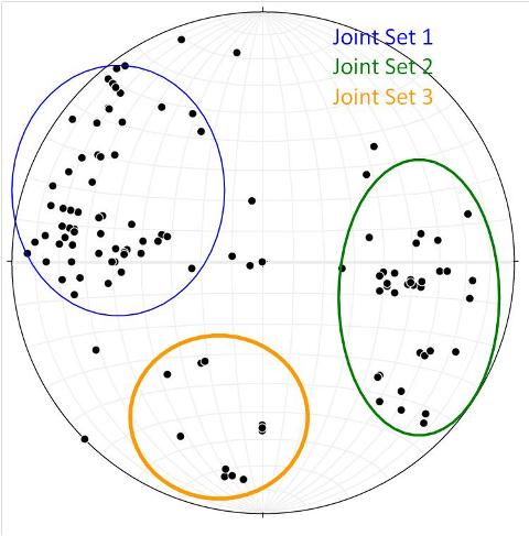
Using stereonets it is possible to identify the major sets of joints present in the Weverton Formation.  They are indicated below.    It is important to notice that all of the stereonets included in this post are using poles to display data for planar features.  I find that poles make paterns more easily recognizable than great circles with large sets of data.


The orientation of the joints is valuable because it can give us an insight into the major stresses acting on the region.  Typically the plane of the joint is oriented parallel to the plane created by the primary and secondary stress directions. (dandd2).  The direction of least principle stress is generally perpendicular to the plane mentioned before.  This being said, this explains joint set 3 as the plain is parallel to the primary stress direction (east- west) during the Appalachian Orogeny.  However, joint sets 1 and 2 are more difficult to explain.  They each appear to be dipping at 50-60 degree angles in opposite directions (roughly east and west).  To me this suggests a conjugate pair of normal faults even though there is no evidence of displacement along the joint faces I examined.  As such, I propose the hypothesis that joint sets 1 and 2 formed during the rifting of pangea (discussed later).  The extensional forces exceeded the tensile strength of the quartzite forming the joints.  Perhaps, this is evidence of a failed right which failed even earlier in its existence than the Culpeper Basin to the east.  Possibly, the extensional stress was relieved by the formation of other basins before the joints underwent displacement.

            Another feature seen in the Weverton is large quartz veins which have proceeded to fill the gaps left by joints.  The stereonet below shows the vein information we have overlaid on the joints from above.  It is evident that the quartz veins followed the pre-existing joints.  This was caused by the high pressures and relatively high temperatures during the Alleghenian Orogeny.  These parameters metamorphosed the sandstone into a quartzite.  Also, some areas of the quartz experienced more extreme conditions and went into solution.  Another scenario is that some areas of the quartz were more pure than others meaning that they required a higher energy conditions in order to melt, which allowed some areas to go into solution and others to not.  The principle behind this hypothesis is that contaminants lower the melting point of a solution similar to putting salt on icy roads in the winter.  Regardless of the cause, the silica solution then moved to the pores (in this case the joints) and then recrystallized.  Interestingly the veins seem to have preferentially formed in what was earlier referred to as joint set 1.

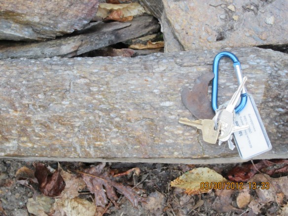
            Another interesting feature in the Weverton Formation was the metamorphism of the conglomeratic sections.  The quartz clasts were made somewhat prolate and aligned.  Thus it has been given the term “stretch pebble conglomerate”.  Sadly, I never saw any in situ so analysis of the stress directions is somewhat pointless.  Since the clasts are prolate, d3 would be parallel to the lineation formed by the quartz clasts.  d2 and d1 would then form a plane perpendicular to d3.  The picture shown below is one of float used to line the path.

The keys are roughly 5 cm long for scale.

As we move farther up column we reach the boundary between the Harpers and the Weverton Formations.  Here we find several valleys which have formed along joint planes.  They are likely part of the overall imbricated thrust fault which runs under the entire Blue Ridge Providence.  This will be further explained later as a overall discussion of the features created by the Appalachian Orogeny.  Since its creation the fault has been weathered and is now only visible as a north-south oriented valley.

Later in the column we came across a kink fold in the Harpers formation.  This fold is one of the more interesting features that we saw today.  That is because it is a prime example of Pumpelly’s Rule which states that small scale structures can tell the story of the regional structure.  The shear of this fold shows a regional shearing “up and to the left”.  This picture was taken looking north which means that the “up and to the left” translates to a shear to the west.  In this case, it provides evidence that this is in fact the eastern limb of an anticline with its center to the west.

Photograph courtesy of Laura S.

The next part of our story deals with the next half of a Wilson Cycle, the breakup of a supercontinent.  The setting is 210 Ma, Pangea has been around for a while and heat is building up underneath it.  The convection causes the crust to begin to pull apart exceeded the tensile strength of the continental plate.  These extensional forces led to the rifting of Pangea.  The center of the rift was what is now the Mid-Atlantic Ridge.   The Atlantic Ocean began to open up between Africa and the Americas.  Below is an image of the paleogeography as Pangea broke apart.

Map by Ron Blakey. 

Another product of this rifting was the failed rifts.  The Newark Supergroup is a set of failed rifts which formed basins running from the post-Pangea rifting which runs nearly parallel to the east coast of North America from South Carolina to New Jersey.  The Culpeper Basin (part of the Newark Supergroup) is located just east of Thoroughfare Gap.  As Pangea split apart a rift began to form just east of the Blue Ridge.  The rift ultimately failed but it left behind a depositional basin which then filled with Mesozoic sediment.  Just east of the gap one can find exposures of the Waterfall Conglomerate which is a formation of the Culpeper Basin.  The contact between the Harpers Formation and the Waterfall Conglomerate marks the dividing line between the Blue Ridge and Piedmont Geological Providences.  Below is a picture of the conglomerate.  It formed as sediment from the Blue Ridge Mountains and points west filled in the basin left by the failed rift.

Just as a side note here, it is important to record the strike and dip of the beds.  The following shows the strike and dip of the Weverton and Waterfall Formations.  (Waterfall is in red)

Both appear to be dipping at ~45 degrees to the east. 

During and after the rifting of Pangea the Blue Ridge Mountains were slowly being eroded by time and weather.  The center of the mountain has since been eroded away; as a result there is a valley where the core of the mountain once was.  Today all that is left is the two flanks of the mountain, one being Bull Run Mountain and the other being the Blue Ridge Mountains to the west.  Also, the Bull Run River incised into the mountain creating what is now Thoroughfare Gap. 

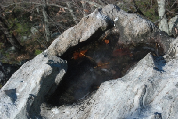
Some other interesting erosional features we found were the opferkessels at the top of the mountain.  Water gets down in pre-existing pits and gets blown around or frozen which enlarges the pit eventually becoming the large bowl shape seen below.  This picture is particularly interesting because it shows the ice in action.


Now that we have covered all of the “small scale” structural features of the area we can begin to understand the forces acting on the area and piece together the mega-scale structure of the region.  All of the evidence points to compressional forces from east to west which is understandable since the three orogenies which make up the Appalachian Orogeny involved terranes moving in a westward direction and impacting the eastern front of the North American Plate.  The folds tell us a story of left lateral shear (when looking north along the Bull Run Mountain Ridge).  Additionally the dip of the beds within the Weverton and Harpers Formations all point east.  At the top of the mountain we looked west through the heart of the Blue Ridge to the current Blue Ridge Mountains.  We were also informed that the formations on that side of the valley dipped to the west.  This indicates that the entire area used to be a massive anticlinorium.  Also, we were informed that the western limb of the anticlinorium is overturned, evidence for which lies in the stratigraphic relationships of the formations found on the western side of the Blue Ridge.  Referring to the picture above, the ridge in the distance is the Blue Ridge Mountain and the area from there to the mountain I was standing on is the weathered out core of the mountain.  Earlier in the post I mentioned imbracated faulting which is associated with low angle reverse faults or “thrust faults”.  Such a thrust fault (with vergance to the west) would result in an overturned limb to the west.  Below is a cartoon west-east cross section of the region.  Its goal was to show Pumpelly’s Rule, however, I thought it gave a great overview of the regional scale structure.

Image courtesy of Callan B.

References

Bentley, Callan. May 2011.  Mountain Beltway: Friday Fold(s): The Outdoor Lab.  American Geophysical Union.  < http://blogs.agu.org/mountainbeltway/2011/05/27/friday-fold-outdoor-lab/>. (19 April, 2012) 

Blakey, Ron.  Paleogeography and Geologic Evolution of North America.  NAU Geology. < http://jan.ucc.nau.edu/rcb7/nam.html> (19 April, 2012)

Buzzard Rock March 2012

This weekend a few friends and I made a trip out west into the Valley and Ridge Province of Virginia in search of some interesting geology.  We were looking for a good hike to stretch our legs along the way.  Professor Bentley suggested that we check out Buzzard Rock located along the Massanutten Syncline.  We were told that along the way we would see some graded beds and cross bedding.  When we started our hike it was a nice gentle sprinkle but while we were on top of the mountain it began to pour, something about one of my fellow hikers challenging the rain gods…  We saw some nice pieces of graded bedding in the debris that had fallen down the mountain (otherwise called float).  This was in what I think was the Martinsburg Formation (Ordovician) along the base of the mountain on the eastern side.  A graded bed is formed by a change in current strength followed by the progressive settling out of sediment from coarse to fine.  One common example is a turbidity current.  A mudslide occurs on the continental slope.  Then, once the sediment reaches the continental rise the sediment motion slows allowing progressively smaller sediment to fall out of suspension creating graded bed which fines upward.  A neat thing about a graded bed is that it is a geopedal structure.  This means that the structure can be used to determine the original orientation of the bed.  The grains always fine up column.  Shown below is one such piece.

And now for the annotation!

Once we got farther into the hike we began to see some interesting cross bedding.  A cross bed is an indicator of unidirectional current.  It shows the motion of particles moved by wind or water being moved along in a ripple or dune.  Coincidentally, cross beds are also geopedal structures.  The side that is truncated points up and the tangential side points down column.  This is because the top section of a ripple or dune is eroded away as it migrates and other ripples/dunes move over it.  As it has it, these cross-beds are small enough to be considered laminae in some books.  This nearly pure while sandstone is indicative of the Massanutten Formation (Silurian).

Below is the same image annotated.  (Sorry for the excessive annotations, just trying to get some practice)

All along the hike we saw some decent examples of cross beds.  However, it wasn’t until we were at the top of the mountain in the Massanutten Formation wandering around in the pouring rain that we hit the jackpot.  We found a cross bed that made the whole trip worthwhile.

And now for the annotated version!

Another interesting thing that we saw was some small scale fluvial geomorphology in action.  With the heavy rain, the water quickly found our trail to be the path of least resistance.  A braided channel pattern quickly developed running down the mountain.  As is typical of a braided channel the braid bars were ephemeral constantly changing position or appearing/disappearing altogether.

Last annotated image for this post, I promise!

Recumbent Fold at the top of the Rockies

Last summer my family took a road trip from Denver, Colorado to the South Rim of the Grand Canyon.  Along the way we stopped at Rocky Mountain National Park.  While there, we took one of the hikes up the mountain along Trail Ridge Road at roughly 12,000 feet.  Recently I was looking through my photographs of the trip and found this amazing fold.  Originally I took the picture to show the interesting lichen growing at altitude.  It was not until I started my structural geology course that I really began to see the structural features present in my past photographs.  This one in particular jumped out at me.  I am used to seeing folds under and in mountains and other regions of tectonic activity.  This one struck me because it was at the top of a 12,200 ft peak.  After thinking about it, I realized that while it was the top of the mountain now, before years of erosion it was deep within the mountain at the Rocky Mountains finished forming some 40 million years ago at the end of the Laramide Orogeny.

This is the outcrop of interest.

Sadly, at the time that this picture was taken I did not realize what I was taking a picture of so I neglected to put anything in the picture to show scale.  The Rock face was roughly three meters wide and this is one meter wide section of it (The fold is shown in its correct orientation).  Below is the same picture annotated.  I have marked only the most obvious fold.  But I can see at least 3 others.

Finally, just to give an idea of the surroundings in which I found this structure, this is a view from near the outcrop.

Billy Goat Trail 3: A Non-Linear Quandary…

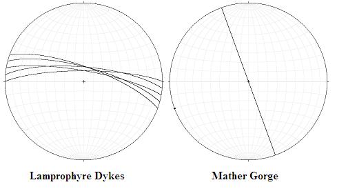
The final pondering point of our day’s adventure was the lamprophyre dykes from the Acadian Orogeny.  There is a distinct disconnect between the Virginia and Maryland Side.  On the North side of the river the dykes are roughly 100 meters downstream from where they enter the water on the Virginia side.  Over the years there have been two theories.  One theory is that when the dykes formed they were continuous across Mather Gorge.  Later there was a right lateral fault which ran parallel to the length of the gorge.  This offset the dyke on either side of the river.  The opposing theory is that there is no fault.  Instead, the dykes were jagged.  The dykes were joint controlled and not planer.

Unfortunately, the turbid waters beneath Great Falls make direct observation of the submerged sections of the dykes impossible.  Because of this another method must be employed to solve this mystery.  During our trip my classmates and I took a series of strike and dip measurements.  We would then plot all of these strike and dip measurements as shown below.


Below is the stereonet of the Foliations.  There appear to be at least two primary orientations of foliation.  One dipping just South of East, and the other to the southwest.


Note: North is up.

Above is a stereonet showing the orientation of the Lamprophyre Dykes.  The dyke set is dipping toward the North-East.  We only had data from the North side of the river, for this reason we are assuming that the dykes have the same orientation on the Virginia Side.  This appears to be the case from what we could see.  On the right is a stereonet showing the orientation of Mather Gorge.

Note: North is up.


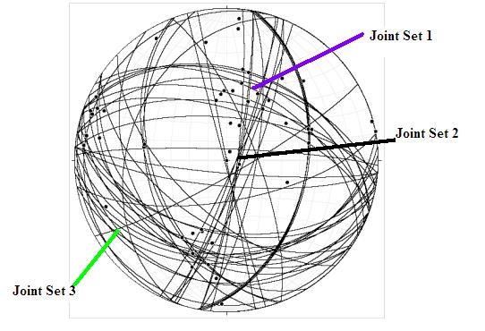
Above is a stereonet showing the joint sets running through the Great Falls area.  There was so much data that the great circles were a little busy to look at by themselves.  Because of this I decided to have the program plot the poles as well.  A pole is the line perpendicular to the plane you are interested in.  In this case it shows three main joint sets, one dipping to the east, one dipping to the south-west, and one dipping to the north-east.  When joints form they tend to do so in response to forces applied across a region.  This causes joints to form in sets all oriented the same direction.


Note: North is up.

This is a stereonet showing the metamorphic foliation found along the Billy Goat Trail.  There appear to be two primary foliation orientations.  One to the North-West and one to the South-East.


            Based on the data collected by my class I do not believe that the Mather Gorge is fault controlled.  As igneous intrusions form they follow the path of least resistance like any liquid trying to find a pressure or potential energy equilibrium.  For this reason it would make sense that the dyke complex would follow the preexisting joint sets.  The data above shows three sets of joints that crisscross the region.  Joint Set 1 has the same orientation as the dykes on either side of the river.  For this reason it is likely that the exposed sections of the dykes above the water line followed joint set 1 on its way toward the surface.  Now that that is settled the question is why the dykes don’t line up on either side of the river.  It is my belief that the dykes may have followed another set to where joint set 1 crossed it again.  For instance, my hypothesis is that the dykes followed Joint Set 1 on the Virginia Side of the river.  Then, where the river is now they followed Joint Set 2 (Which is at roughly a 30 degree angle to Mather Gorge) East.  Then at some point under the present river the dykes intersected and joint from Joint Set 1 and continued North to the exposure on the Maryland shore.

Billy Goat Trail 2: Fancy Features

This post will hopefully explain some of the more interesting structural features that we found along the trial and explain their geological significance for the Billy Goat Trail region in the grand scheme of things.  I am going to try to follow chronological order of creation when talking about the features.

Our first feature is one of the more intriguing rocks in the park.  This is because of its mysterious background.  Along the eastern portion of the trail where metamorphism was at its most extreme there are large exposures of amphibolites.  This is a black metamorphic rock containing amphibole (Thus the name “amphibolites”).  It is recognizable by its alligator skin like texture.  It is crosscut in several places by granitic dykes indicating that it is older than granite.  Potassium argon dating of the granite shows it is roughly 450 million years old.  This means that the amphibolites predate the Taconian Orogeny.  There are two theories for the origin of the amphibolites.  First is that they are an ancient piece of oceanic crust which was obducted while the Iapatus Ocean was being subducted beneath the North American Plate.  The second and more likely option is that it formed as a mafic intrusion in the forearc basin.  The amphibole rich mafic intrusion was altered to amphibolite during the Taconian Orogeny.


This is an amphibolite seen in the eastern portion of the trail.  Photograph courtesy of Callan B.

The next feature was being created at roughly the same time as the aforementioned amphibolites.  Throughout the region graded beds are visible in the Metagreywacke.  The greywacke is sediment that was deposited in the Iapatus Ocean along the continental shelf.  Then, by one cause or another there was a submarine landslide or other event which disturbed a large portion of the sediment.  Then the sediment settled with the largest grains falling out first.  The smaller particles then fall out.  This creates a gradient particle size from coarse at the base to fine at the top as shown in the picture below.  It is important to note that the greywacke has been lightly metamorphosed.

Above is an amazing example of a folded graded bed.

Following the trend of increasing metamorphism, the next feature we come across is schist.  This is where all of the minerals in are aligned during pressure metamorphism.  The grains are typically aligned in a plane perpendicular to d1.  The alignment of micas and other grains is called foliation.  This is shown in the picture below.  This is a relatively low grade of metamorphism, but higher than the metagreywacke talked about above.  Sadly, none of the pictures I took, nor those I had access to of my classmates did the schist justice and so are not included here.

We next found gneiss.  This is caused by a higher grade of metamorphism than we had seen before.  In gneiss the light and dark color minerals (particularly the feldspars and the micas) align in bands.  This is called “Gneissic Banding”.

Above is a picture of gneiss courtesy of Laura S.

The next important features we saw were migmatites.  Migmatites form when under the intense temperatures and pressures of metamorphism partial melting occurs.  In Great Falls the migmatites formed as the greywacke partially melted.  The partial melt created granite.  The blebs of partial melt then start to rise toward the surface. 


These are migmatites caught in the process of forming. Photo courtesy of Laura S.

In addition to the diversity of rock types mentioned above there were an assortment of folds and other strain indicators.  Shown below is one of the best folds that we found.


Photo courtesy of Laura S.

Additionally, there was the ptygmatic folding shown below.  The shortening could be measured and used in conjunction with other markers to find the overall strain on the region.  The term ptygmatic describes the intestine-like shape of the fold.

Another feature we found in the park was boudinage.  Even more interesting was the chocolate tablet boudinage we found near the end of the hike.  A boudinage is where a somewhat brittle material is elongated and becomes tapered in places.  Sometimes it can even break.  The more malleable material surrounding then fills in.  It begins to look something like sausage links.  Chocolate tablet boudinage is where this happens in three dimensions. As seen in the picture below.

There is also the matter of jointing.  Joints occur along weak planes in the rock structure.  These fractures propagate throughout the rock.  They tend to form as sets.  There is no motion of either side with respect to the other associated with joints.


Above is an image of jointing on the Rocky Island.

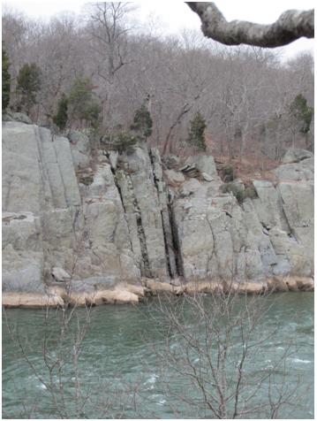
The most recent geological feature of region are the lamprophyre dykes.  They formed during the Acadian Orogeny.  The dykes are mafic intrusions into the surrounding greywacke.  They dykes are very visible on the Virginia side of the Potomac.  However, along the Billy Goat Trail the dykes are barely noticeable unless you know where to look.  The best evidence of the dykes on the Maryland side are the straight, narrow gaps in the country rock where the dykes were and have since been eroded.  An interesting detail is that the dykes do not line up across the river.  The possible causes of this will be the subject of the next post.


The Lamprophyre Dykes are marked below.


References

Bentley, Callan. GOL 135: Geology of the Billy Goat Trail, including Great Falls, Maryland.  Northern Virginia Community College: <http://www.nvcc.edu/home/cbentley/gol_135/billy_goat/readings.htm&gt;, (20 Feb. 2012).


Billy Goat Trail 1: Introduction


As part of my structural geology course at George Mason University we went on a Field Trip to the Billy Goat Trail near Great Falls on the Maryland side of the Potomac River.  After the field trip we were asked to make a report of what we saw and learned on the trip.  We were given the choice of any medium we wanted.  I chose to create a blog to explore the style of writing and the interaction with other people in the field or with similar interests to my own.  And thus we have reached the purpose of this entry.  In this entry and the following two I hope to give a relatively brief introduction to the area and its geologic past, discuss some of the more interesting structural features we found during our trip, and finally discuss the structural features controlling Mather Gorge and the Lamprophyre dykes.


      Each year thousands of people visit the Billy Goat Trail.  Only a small fraction of those people are able to appreciate the geological significance of the area.  The region covered by the trail shows evidence not one but two of the three major orogenies which have influenced the eastern portion of the North American Plate.  Also, the Potomac River has heavily altered the region by incising and creating the Mather Gorge.

This map depicts the Maryland side of Great Falls; the blue circle marks our study area.  (Photo Courtesy of the National Park Service)

The Billy Goat Trail is located within the Chesapeake and Ohio Canal National Historical Park which runs from Cumberland, MD to Washington D.C..  The canal was the brain child of George Washington who sought to overcome the topography created by the very geology that makes the region so special.  Up until the canal was built it was impossible to transport goods by water past the “fall line”.  This is the name given to the dividing line between the Piedmont and the Coastal Plane Regions of Virginia.  This marks a transition from easily eroded rocks to the more resistant rocks of the Piedmont and western regions.  The more resistant material creates waterfalls and shallow rocky regions making the area impassible for boats.  Thus another means of transporting goods was required and the canal was begun.  Unfortunately, with the advent of the steam engine not long after completion of the canal soon made it obsolete.  The canal fell into disuse until a Supreme Court Justice, one William Douglas who led the fight to get the entire canal made into a National Historical Park which people would be able to enjoy.

The fantastic geology found along the trail is a product of the tectonic activity which has taken place over the course of the last 500 ma or so.  To better understand the features visible along the trail and to see some of the more subtle overall trends one must first understand the tectonic history of the region.

510 million years ago the eastern what would be the eastern seaboard of the United States was the continental shelf of the North American.  The Instead of the Atlantic Ocean it was the Iapetus Ocean.  Not far off the coast was the Chopawamsic Terrain, an ancient volcanic island arc which was moving toward the North American Continent.  The oceanic crust along the edge of the North American Plate was being subducted since the oceanic crust was less dense than the continental crust under the island arc.  As the slab was pulled down into the mantle rising temperature and the presence of volatiles caused partial melting to occur.  The melt then moved up to the surface above the sinking slab supplying magma to the volcanic arc, this added to the size of the volcanic island arc.  Then, after roughly 60 million years of suspense, the oceanic crust between the two landmasses ran out and they collided.  In the words of Professor Bentley, it was like a Volkswagen Beatle getting into a head-on collision with a tractor trailer.  There was some strain on the part of the east coast of the ancient North American Plate but on the whole it remained relatively undamaged.  The Chopawomsic terrain however was smashed onto the leading edge of North America.  In other words it was accreted.  The deformation caused by the collision of the two landmasses created the majority of the geologic features found along the Billy Goat Trail.  The collision is known as the Taconian Orogeny.  The 450 Ma date of the orogeny was confirmed by potassium argon dating of the granite migmatites.  The Taconian Mountains were the end result of the collision.  The level of metamorphism of the features along the trail increases from west to east indicating that the heart of the Taconian Mountains was east of Great Falls near Washington D.C..  The Taconic Mountains in New York are the only remaining mountains of the ancient mountain range.  However, the rocking and hilly nature of the Piedmont Providence of Virginia can be attributed to being the roots of the Taconian Mountains.

Below is an image of the North American Plate before the Taconian Orogeny. (Figure Courtesy of Callan B.)


This is a picture of the North American Plate just after the Chopawamsic Terrain collided with it.  The micro-continent Avalonia can be seen moving in from the North East. (Figure Courtesy of Callan B.)


For the next 100 million years the east coast was quiet with very little happening, that is until the Acadian Orogeny.  Around 350 Ma another continent, Avalonia, swept in from the North and collided with the North American Plate.  This date is corroborated by the radiogenic dating of the lamprophyre dykes.  The primary impact occurred in the North from roughly what is New York up into Canada.  For what would eventually be the D.C. Metropolitan area, the collision was a glancing blow.  There was very little metamorphism in the area associated with the Acadian Orogeny.  In fact, along the trail the only piece of evidence of the mountain building event is the lamprophyre dykes.

Since the Acadian Orogeny there has been very little activity in the region aside from weathering.  The Potomac River has likely had the biggest impact on the topography of the area.  In the past it was a meandering river which wandered back and forth across what is now the Virginia-Maryland State Line.  Channel Lag and other indicators of the Potomac’s ancient path ranges deep into Virginia.  For instance I have seen places in cascades south of VA-Route 7 where the larger sediment deposited by the Potomac has caused the area to resist erosion and become a large hill.  Other evidence of the past elevation of the river are straths or terraces.  These show the ancient floodplains of the river from when it was meandering.  Straths look something like a giant’s set of stairs on either side of the river leading down to the river.  They are caused by the river incising.  Then the river meanders creating a flat area around it.  Later the river incises again and repeats the process.  The majority of our hike took place on the Bear Island Strath.

Later, during the past ice ages sea level was much lower than it is today.  This caused the river to have more potential energy (p=mgh, where p is potential energy, m= mass, g is gravity, and h is height).  This increase in potential energy caused the river to erode the sediment rather than deposit.  The augmented erosional power of the river caused it to incise and become entrenched as it is today.  The incision created Mather Gorge.

References

Anonymous, Feb. 2012,  Great Falls Park.  U.S. National Park Service: < http://www.nps.gov/choh/planyourvisit/upload/greatfallstrailmap.pdf&gt;, (27 Feb. 2012).

Bentley, Callan. GOL 135: Geology of the Billy Goat Trail, including Great Falls, Maryland.  Northern Virginia Community College: <http://www.nvcc.edu/home/cbentley/gol_135/billy_goat/readings.htm&gt;, (20 Feb. 2012).